


![]()
Trimble UX5 Multispectral Unmanned Aircraft System
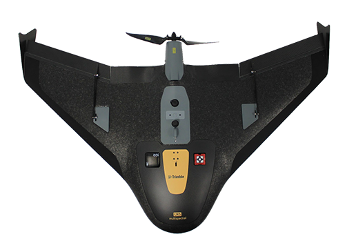
Trimble UX5 Multispectral Unmanned aircraft system is designed to capture true multispectral data for vegetation mapping. The Trimble UX5 Multispectral combines the power and reliability of the Trimble UX5 platform with the precision and dependability of the 5-band MicaSense RedEdge™ narrowband multispectral camera.
- Superior Multispectral image quality with the MicaSense RedEdge
- Option to connect a Downwelling Light Sensor offered by MicaSense to enable continuous ambient light corrections
- Offers class-leading coverage area per flight without compromising on lateral overlap, again important to avoid degrading
- Minimizes variations in orientation angles within flight lines
- Captures the highest quality data in difficult conditions
Trimble Access Aerial Imaging Application
The Trimble Access Aerial Imaging application operates the UX5 Multispectral and is a single software tool for planning your aerial missions, performing pre- flight checks and monitoring your flights.
- Simple User Interface supports all of the functionality
- Ensures correct operation of the MicaSense RedEdge
- Maps any shape of field, change landing location during flight, and perform flight simulations to validate flight plans
- No piloting skills required
- Built-in safety procedures ensure safe and successful launches each time
- Easily integrate with the MicaSense ATLAS™ cloud upload tool or any other Micasense-compatible image processing tool